Social
Meta
Meta
Category Archives: Flying
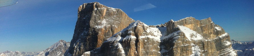
Flying the Dolomites
November can be an incredible month for flying the Italian Alps… Batteries recharged, no further comments required!
Volare
It’s been a while since I posted a flying picture … This is where you can find me this week!
Flying to Trieste
Saturday morning, against all weather forecasts, I found the perfect conditions (CAVU) to attempt a flight as East as I had ever been before. Well, I was born there and dreamed of seeing it from above for so long… Seen from … Continue reading →
Flying Italy, North East
Now that the Italian North East air space has been opened up a bit removing (at least during the week ends) massive restrictions that represented the legacy of the cold war era, flying a small two seater (Tecnam P92) … Continue reading →
Flying Europe Now!
So it is official, I ‘ve added a JAA (European) Pilot License to my resume! It took me a lot of patience and perseverance to work through all the nonsense and abuse of the Italian bureaucracy, but eventually I got … Continue reading →
Landing on a Carrier
Navy pilots will tell you that landing on a carrier is one of the most challenging maneuvers in aviation but also, as often is the case, one of the most rewarding. In Arizona there are no bodies of water that … Continue reading →
KTUS
This past weekend I found another perfectly good excuse to spend a Saturday flying across Arizona. Ivan, a friend from the old continent, sent me an email during the week, he was in Arizona for company training but stuck without … Continue reading →
Playing Poker along the Colorado River
Oh the things a pilot would not do just to find an excuse to fly some more! Well, gambling is one of them! For the fourth year in a row, the last week end of January, a benefit Poker Run … Continue reading →
Flying along the Salt River
Probably most of you will think of Arizona as one flat desert place, but that is quite a mistake. Actually 70% or Arizona surface is covered by mountainous terrain. It is true though that 90% of the population do live … Continue reading →


